

Should the Federal Government Sell Land?
An early version of the US Senate budget bill which passed last week included a provision to sell off between 2 and 3 million acres of federal land in western states, ostensibly to be used for homebuilding. Due to widespread public opposition, the proposal was removed prior to the bill being passed, but it sparked a nationwide conversation about federal land ownership and whether it makes sense to sell off federal land. Conservation-minded folks on the right and the left were strongly opposed to any sort of large-scale land sale, arguing that federal lands should be protected for environmental and/or recreational purposes. Others argued that much of this land has little recreational or environmental value, some of this land is located near dense population centers, and we should consider selling parcels like these rather than demanding a blanket moratorium.
I wanted to better understand issues of federal land ownership, so I spent the last week mapping land and population data in the western US. For federal land ownership data, I used the PAD-US database maintained by the US Geological Survey. For topography data, I used Shuttle Radar Topography Mission (SRTM) data from OpenTopography.com. For population data, I used the US Census, including census tract shapefiles. By mapping this data, I got a detailed look at the extent and nature of federal land ownership, and to what degree areas of high housing demand could benefit from opening up federal lands for development.
I found that only a small number of major cities (notably Las Vegas, and to some extent Phoenix, Boise, and Tucson) could take advantage of opening up unprotected federal land for development. Most large cities in western states are adjacent to large tracts of federal land, but most of this land is unsuitable for development, either because it’s mountainous or because it’s a protected area such as a National Forest or Wildlife Refuge. Millions of acres of federal land actually are practical to develop, including some abutting population centers, so it doesn't seem unreasonable to me to open up some of it — but I also don't expect such development to substantially increase housing availability in western states because most of it is not near large population centers with high housing demand.
Note: It’s surprisingly difficult to get precise figures for federal land ownership. Only a few scattered government reports list overall land ownership figures; and they’re often out of date, incomplete, or in conflict with each other. This 2018 CRS report on federal land ownership notes that “figures understate federal lands in each state and the total in the United States” because only lands managed by five major federal agencies are included. This GAO report says the federal government owned 724 million acres in 1990, but this one gives a figure closer to 620 million (the latter is almost certainly correct, but it makes things hard when reports like this conflict). Agencies will often manage land that isn’t federally owned but is still protected from development (2.6 million acres of private land exist within National Parks) or share management over acreage with another agency (both the National Park Service and the Bureau of Land Management manage Grand Canyon-Parashant National Monument). Different categories of federal land often overlap (the San Gabriel Mountains National Monument overlaps with the Angeles and San Bernardino National Forests), which can make it tricky to extract federal land area values from GIS datasets like PAD-US. All this is to say that all figures provided for land areas below should be regarded as approximate.
Federal land ownership
The federal government is the largest landowner in the US. Of the 2.26 billion acres of US land area, the US government owns ~615 million acres, or ~27%. The state of Alaska makes up over ⅓ of federal land at around 220 million acres. Of the remainder, ~350 million acres is concentrated in 11 western states, where the government collectively owns ~45% of the land.

Most federal land is administered by a small number of federal agencies:
244 million acres, 177 million of which are in western states, are under the purview of the Bureau of Land Management (BLM). Some BLM land is protected for conservation, but much of it is available for things like livestock grazing, coal mining, and oil and gas (and geothermal) drilling.
193 million acres of National Forest (and National Grassland), 133 million of which are in western states, are managed by the US Forest Service.
89 million acres of wildlife refuges, wilderness areas, and other protected lands are administered by the Fish and Wildlife Service. Most of this land (~76 million acres) is in Alaska.
80 million acres of National Parks are managed by the National Park Service. As with the Fish and Wildlife Service, most of this land (52 million acres) is in Alaska. Seven of the 10 biggest National Parks are in Alaska, with the largest (Wrangell-St. Elias, 13.2 million acres) being bigger than “Yellowstone National Park, Yosemite National Park, and Switzerland combined.”
8.8 million acres are owned by the Department of Defense.
For most of its history, the policy of the US government was to sell off, donate, or otherwise dispose of federal land holdings so they could be used for productive purposes. Over the course of the 18th and 19th centuries, the geographic area of the US steadily grew through land purchases and conquests, from 568 million acres in 1790 to 2.3 billion acres in 1867. Most of this land — 1.8 billion acres worth — was at one point owned by the federal government, but by 1990 roughly 1.2 billion of acres of it had been transferred to state or private hands:
360 million acres were given to states
287 million acres were given freely to homesteaders
94 million acres were given to railroads
40 million acres were given to Alaska natives
And 400 million acres were sold, given away, or otherwise disposed of
However, in 1976, the government’s policy towards land disposal officially changed with the passage of the Federal Land Policy Management Act. The act repealed previous homestead acts used to give federal land to homesteaders (along with thousands of other land laws), declared that “it is the policy of the United States that the public lands be retained in Federal ownership,” and tasked the Bureau of Land Management with administering public lands. Since then, outside of a transfer of roughly 100 million acres of federal land to Alaska and Alaska natives in the 1980s, the land area owned by the federal government has remained roughly constant.
Making use of federal lands
Outside of Alaska, most federal land is in western states, making up nearly half of total western state land area. And as I noted in a previous essay, western states are burdened with very high housing costs compared to the country as a whole. On its face, then, selling some of this federal land and using it to build more homes, or for development more generally, isn’t an obviously crazy idea.
There are several challenges with selling off federal land for housing or development. First, most of this federal land isn’t anywhere near where the demand for housing is. The map below shows all federal land in western states in green, and federal land that’s more than 20 miles from a population center (defined as a census tract with population density greater than 100 per square kilometers)1 in purple. We can see that most federal land — roughly 250 million of 350 million acres, over 70% — is very far from any sort of population center, and thus from most housing demand.

The second challenge is that most federally owned land in western states is earmarked for conservation or otherwise ineligble for sale.
26.5 million acres of federal land in western states are National Parks, Wildlife Refuges, Wilderness Areas, and similar tracts administered by the National Park service and the Fish and Wildlife Service and are protected from development.
Over 13 million acres of BLM land is National Monuments, conservation areas, and other tracts that are likewise protected.
141 million acres of federal land in western states are protected National Forest and Grassland, administered by the Forest Service. While these areas do allow some extractive uses, such as logging, they’re ineligible for sale outside of a few narrow exceptions.
Altogether ~209 million acres of federal land in western states (~60% of all federal land) are protected from development in some way.2

Changes to the law could allow protected areas to be sold, but in practice this is politically difficult, if not impossible — the recent Senate land sale proposal originally included areas of National Forest (comparatively less protected than things like National Parks and National Monuments) as eligible for sale, but later versions of the land sale proposal dropped this due to widespread opposition.
A third barrier to selling off federal land for private development is that much of the federal land in western states is mountainous and impractical for development. The map below shows areas in western states where the ground slope exceeds 20%. Altogether ~85 million acres of federal land in western states is too steep for practical development.

In practice many cities that appear to be hemmed in by federal land (and thus seem like they would benefit from opening it up for development) are actually just surrounded by mountains. Selling off the land wouldn’t change the practicalities of building on it.
Below, for instance, is Salt Lake City. You can see that its eastern edge butts up against federal land (green), and that it’s also blocked from expanding by lakes and wetlands to the north and to the south, and by the Bingham Canyon Mine and Camp Williams to the southwest. Salt Lake City also has expensive housing: census tracts where the ratio of median home value to median household income is greater than five are shown in yellow. Just looking at this map, it might seem like it would make sense to open up some of this federal land to housing development and give the city more room to expand.

But a topographic map (or, you know, an actual picture of Salt Lake City) reveals that this federal land is highly mountainous, making it impractical for development even if the federal government did sell off the land.

Similarly, Los Angeles is hemmed in by mountainous federal land to its north:

The area around Lake Tahoe is similarly surrounded by mountainous federal land.

If the vast majority of federal land in western states is impractical to develop on, how much is actually practical to sell off for private development?After subtracting protected areas, land far from population centers, and land that’s too mountainous to develop, you’re left with ~26 million acres, or less than 8% of total federal land area, suitable for private development in western states. This is shown below in purple:

While 26 million acres is small proportionately, it’s still very large in absolute terms: greater than the land area of Austria (20.7 million acres), Switzerland (10.2 million acres), Iceland (25.4 million acres), or Ireland (20.8 million acres). And while much of this land doesn’t seem particularly urgent to open up for development (the area around Powell, Wyoming isn’t exactly a burgeoning metropolis in need of expansion), some areas seem more promising.

The most obvious candidate is Las Vegas, which is hemmed in on all sides by federal land. Much of this is protected: the Desert National Wildlife Refuge to the north, Red Rock Canyon National Conservation Area to the west, the Rainbow Gardens and River Mountains Areas of Critical Environmental Concern to the east, and the Sloan Canyon National Conservation Area to the south.

But not all the land around Las Vegas is protected. In some cases, you have dense development across the street from completely empty federally-owned desert. It’s not unreasonable to think this land would be better used for home construction.

Grand Junction, Colorado similarly has expensive housing, and is hemmed in by federal land on all sides. Some of this is protected and/or mountainous, but not all of it.


Boise, Idaho is another city with expensive housing, and places where development is abutting empty, unprotected federal land.

As is Redmond, Oregon.


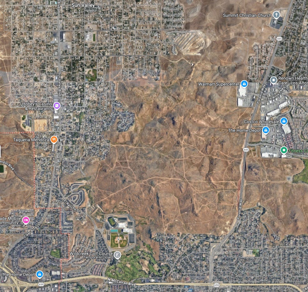
Reno, Nevada has a huge tract of empty federal land right in the middle of the city.

Conclusion
While almost half the land in western states is federally owned, the vast majority of this land is impractical for development purposes. It’s either too far from population centers, protected for conservation and/or recreational purposes, or unsuitable for development due to its terrain. But in absolute terms, a small fraction of hundreds of millions of acres is still a lot of land. It’s not hard to find cities in the western states that have high housing costs, and are abutting empty, unprotected federal land. This isn’t land that’s National Parks, or monuments, or National forests, or wildlife refuges, or protected wilderness. It’s just empty, unused acreage. It doesn’t seem unreasonable to sell some of it off to make better use of it.
However, I don’t expect that such land sales would have a major impact on housing costs in western states. Although there’s some developable federal land near population centers, little of it is located near major western cities. The image below shows federal land around the 20 largest metro areas in western states, which together have ~70% of western state population. Of these, only Las Vegas, Boise, Tucson, and Phoenix have developable federal land adjacent to the city. (And really only Las Vegas combines large, developable federal tracts near the city with little available land elsewhere in a way that I expect could have a substantial impact on housing prices.) While most large western cities (16 of the 20 largest) do have federal land adjacent to them, it’s mostly mountainous and/or protected from development.
(Click image below to enlarge.)

So while it seems worthwhile to consider selling some parcels of federal land near population centers, most major cities wouldn’t benefit from this all that much.
87% of the population in western states lives in a census tract at least this dense.
Federal lands flagged as ineligible for development:
National Historic Site
National Battlefield
National Conservation Area
National Recreation Area
National Lakeshore or Seashore
National Scenic, Botanical or Volcanic Area
National Park
National Monument
National Trail
National Forest
National Grassland
National Wildlife Refuge
Wild and Scenic Rivers
Wilderness Area
Area of Critical Environmental Concern
I agree with the other commenters, great article, very timely and informative. It is interesting though that the other major limiting factor for growth in western cities was not mentioned: water. For example lake Mead, the water source for Las Vegas almost went below minimum pool A few years ago, and future water shortages are on the horizon.
Couple of things
First Shawn Ryan interviewed Braxton McCoy (episode 213)
And Braxton mentions that the states already have a means of selling/developing fed land. The “problem” from the politicians view is that they have to justify every acre, every time, on a need basis.
Secondly
This is sadly rather political
If the land is used for “affordable” housing then the western states do not have the population necessary to maintain 2 party “equilibrium”
Meaning they will flip to being heavily Democrat. guessing based on how most “affordable” housing districts vote already.
But let’s be real
the main reason they want it sold off in mass is to profit…